


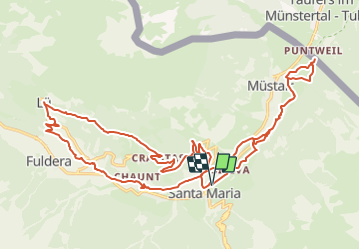
Kreuz und quer im Val Müstair

bffcuc
User

Length
27 km

Max alt
2045 m

Uphill gradient
1038 m
Km-Effort
41 km

Min alt
1225 m

Downhill gradient
1044 m
Boucle
Yes
Creation date :
2014-12-11 00:00:00.0
Updated on :
2014-12-11 00:00:00.0
7h23
Difficulty : Unknown

FREE GPS app for hiking
 SityTrail
IGN / Geographical institutes
SityTrail Plus
The world is yours!
About
Trail Other activity of 27 km to be discovered at Grisons, Region Engiadina Bassa/Val Müstair, Val Müstair. This trail is proposed by bffcuc.
Positioning
Country:
Switzerland
Region :
Grisons
Department/Province :
Region Engiadina Bassa/Val Müstair
Municipality :
Val Müstair
Location:
Unknown
Start:(Dec)
Start:(UTM)
609268 ; 5162101 (32T) N.
Comments